What is Domaining?
In geology, a geological domain refers to a specific area or volume in which the characteristics of mineralization are relatively uniform when compared to the surrounding areas. The process of modeling geological domains, also known as domaining, involves generating 3D shapes, typically referred to as wireframes or domains. The underlying assumption is that the mineralization controls are monogenetic, meaning that they are produced by a single process, and that the data within the domain exhibit a monomodal distribution of sample values. By creating these domains, geologists can simplify the complex data sets associated with mineral deposits and develop more accurate estimates of mineral resources.
Why is Domaining Important?
The fundamental principles of estimating the average grades of mineral deposits are based on statistical behaviour. It is necessary to ensure that the domains in which we estimate the grade and tonnage, are stationary. This means that the characteristics of the deposit within a given domain should remain constant, so that the statistical models used to estimate the grades are reliable and accurate.
Understanding the Difference Between Geological Domains and Estimation Domains
Although they may sound similar, geological domains and estimation domains are not the same. Geological domains are primarily based on geological data, such as lithology, rock and alteration types, resulting in multimodal distributions or trends in sample data within a single domain. Figure 1 shows an example of 3-dimensional geological model exhibiting 4 different geological domains. On the other hand, estimation domains are created based on sample data showing spatial grade continuity and statistically exhibiting monomodal distribution. Figure 2 shows an example of two separate estimation domains.
To create reliable estimation domains, geological and numerical data must be evaluated together. Exploratory Data Analysis (EDA) helps in understanding the existence of several populations with significantly different summary statistics. Micon’s experience suggests that the combination statistical characteristics of the data, coupled with geologic knowledge, leads to reasonable a division of the deposit into domains for estimation.
Additional Information Regarding Estimation Domains
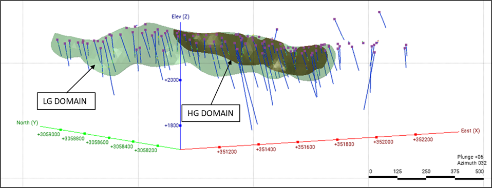
The aim of creating an estimation is to accurately represent the distribution of mineralization based on its grade continuity. It is important to determine a reasonable cut-off grade (COG) that aligns with the characteristics of the mineralization being studied, considering the chosen mining method. In certain instances, the estimation domain may exhibit multiple distinct grade populations. It is essential to carefully identify and separate these grade populations. For instance, there could be a high-grade (HG) domain present within a larger low-grade (LG) domain. Figure 3 depicts an illustration of such a scenario, with a HG domain surrounded by a halo of LG domain.
Figure 1: Example of Geological Domains
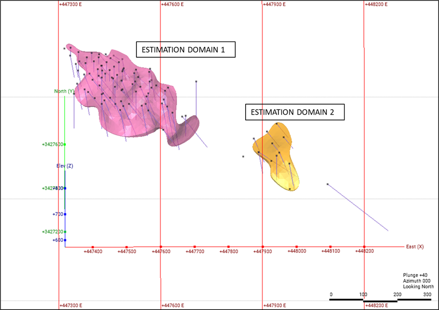
Figure 2: Example of Estimation Domains
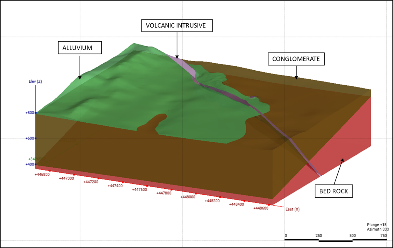
Figure 3: HG Domain Contained within a LG Domain
Things to Keep in Mind
- Sound geological knowledge about the deposit to be modelled is necessary. Proxies for geological information (such as geophysical, geochemical and petrophysical data) are a significantly underutilized resource that can provide important information on structure, mineralization geometry and other.
- If grade-based domains (grade-shells) are being used as estimation domains, the cut-off grades to delineate the grade-shells need to be chosen judicially. The distribution of the elements of interest and the continuity of grade are most important when choosing domains. Economic cut-off grades or combined multi-element grade cut-offs based on element conversions are not appropriate.
- Always carry out a boundary analysis. Boundary analysis is an important tool to investigate whether ore-waste contacts are abrupt ‘hard’ or gradational ‘soft’ boundaries. This analysis not only provides important input for the estimation process but can also reveal important trends around the contact that could potentially invalidate the supposition of stationarity in the domain.
- Implicit modelling tools should be used wisely. Nowadays, several implicit 3D modelling tools are widely available, but inexperienced operators should be wary about creating inaccurate models that depict mineralization as a jumbled mixture of «blobs», that are not representative of the true geology.
Summary
The process of building domains is typically an iterative one that involves using both geological and numerical data to construct, validate, and refine the domains. Geology should always be the primary factor in determining the domains, and the final model should accurately reflect the actual rock formations. Micon’s experienced resource geologists use effective and sensible workflows that combine estimation domains with geological domains to achieve robust models. The crucial steps of building domains, analyzing data within each domain, and readjusting the domains are essential to obtaining meaningful and accurate estimates of mineral resources.
0 Комментариев